Hiking Maps (登山地図 - tozan-chizu)
In most outdoor shops and most bookshops you will find several brands of hiking maps. There are two main brands that have 1:50,000 scale plastic maps (with greater details for certain places) that cover most popular hiking places in Japan.
The one I always preferred was Yama-to-kogen chizu (山と高原地図) sold by Mapple I think.
https://www.mapple.co.jp/product/mountainmap/
There are phone Apps with these maps but I prefer to use the real thing rather than digital with a small area visible so not useful for planning routes and if your battery dies there is no map.
Yamakei also have free online map access with 'some' details (not all).
https://www.yamakei-online.com/yk_map/
You can also buy paper Japanese survey maps that are 1:10,000 scale for the best contour detail. They do not have other useful information that the maps above have (hiking times, route descriptions like danger points, water springs, lodges, campsites, bus and taxi hone numbers).
They do not show all the hiking paths or the different grades of path (major, minor - not maintained, old, old minor paths). They do cover ALL of Japan though which other maps do not. If you go the less popular areas, off path etc then they are useful.
There is also online access which you could print yourself and use to study an area (scroll/zoom in/out):
http://maps.gsi.go.jp
The Best Hiking Compasses
A lot of different opinions on brands. I have a good Suunto compass but Silva are popular.
The Suunto A-30 compass with metric scales looks good - it has a large magnifier to study detail when needed, at night, and in bad weather. It is cheaper than the Silva Expedition one.
COMPASS - THIS ONE is very cheap and has everything needed. Not sure about quality but it has most of the best features needed - and price. The company do sell good stuff though!
https://www.lifesystems.co.uk/products/ ... on-compass
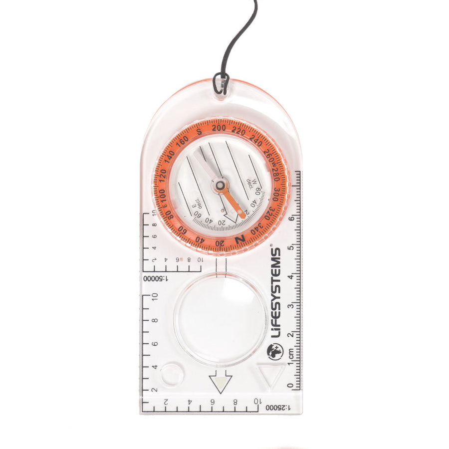
Features of a Good Hiking Compass
1. Plastic Baseplate
Long flat clear baseplate. Easy to read map below and to measure for long bearing and for distance.
2. Circular Housing Bevel
This turns and should be easy to grip with gloves on but firm so it does not move unintentionally after the bearing is set.
3. Measuring Scales
Depends which country you are using. Most countries now it is metric.
I recommend a long mm/cm scale which I use most. After that 1:25,000 and 1:50,000.
4. Magnifier
Used to see small map details. Better larger if you can get one - often orienteering compasses. If smaller they cast a shadow over details at night when using a headlight.
5. Magnetic Needle
One that does not swing too much when using (settles quickly) but does not stick to easily (when trying to hold level).
6. Price
Depends what you are using for. If it is just navigation training and not taken often then a cheaper one ok. If carried often and in places maybe 'off path', bad weather etc, then spend more.
A good compass with these features probably costs around 3,000-5,000 yen. Cheaper ones maybe 1,500yen that are ok.
These are main points for me... other details are similar for all compasses.
Sighting compasses with parts that bend up to target something are not much use, easy to break, and probably no more accurate than a simple flat baseplate design (reasons explained in navigation lessons).
Some photos of recommended design - not promoting any particular brand.